.comment-link {margin-left:.6em;}

RIVERS AND STREAMS

"In rivers, the water that you touch is the last of what has passed and the first of that which comes." Leonardo da Vinci.

Sunday, April 01, 2007

Generated Image

A river is a large natural waterway. The source of a river may be a lake, a spring, or a collection of small streams, known as headwaters. From their source, all rivers flow downhill, typically terminating in the ocean. The mouth, or lower end, of a river is known as its base level. A river's water is normally confined to a channel, made up of a stream bed between banks. Most rainfall on land passes through a river on its way to the ocean. Smaller side streams that join a river are tributaries. The scientific term for any flowing natural waterway is a stream; so in technical language, the term river is just a shorthand way to refer to a large stream.
read more at http://en.wikipedia.org/wiki/River

Saturday, April 29, 2006

The Science of River Restoration


What basic principles do rivers adhere to? and can we restore a river if it has been degraded in some way?

The first question was first addressed, or at least one of the original persons, by Luna Leopold. He saw similarities in rivers and streams of different sizes and in different regions. If you have been to more than one river or stream then you know they can be quite different and in fact I contend that each one is unique. So what qualities or characteristics do they share. Well thats one of the things Luna found. He found patterns similar to many streams such as the meandering pattern, radius of curvature, width and depth ratios to name a few. These are all governed by the laws of physics. Patterns in nature have always fascinated me as well as many others I am sure. more to come have to do actual work

Friday, April 28, 2006

What lives in streams?


What lives in strems? well two things are insects and fish ofcourse. Pictured above is a mayfly or Ephemeroptera. This is its adult stage where it may only live a short time (1-2 weeks or shorter) before it dies. Its main goal at this time is to mate and pass on its genes. Since they live a short time they may not have any functioning mouthparts and therefore don't eat. Amazing right? I must admit since studying stream organisms I have a new found fascination for the little buggers. The picture below is a newly hatched fish, trout to be specific. This one is from the Family Salmonidae.

Friday, April 21, 2006

Is your Eco-Footprint like Bigfoot's? Now you can find out.

Everybody (from a single individual to a whole city or country) has an impact on the earth because they consume the products and services of nature. Their ecological impact corresponds to the amount of nature they occupy in order to live.

The ecological footprint (or eco-footprint for short) is a tool to measure our ecological performance. It tracks how much individuals, organizations, cities, regions and nations, or humanity as a whole consumes and compares this amount to the resources nature can provide. More precisely, it shows how much biologically productive land and water area a given population occupies to produce all the resources it consumes and to absorb its waste, using prevailing technology

April 22 is Earth Day, how about taking 10 minutes to find out your own personal "ecological footprint" http://www.myfootprint.org/

Know what a 'Yazoo' stream is?

A yazoo stream is any stream that runs parallel to, and within the floodplain of, a larger river that the stream eventually joins. Where the two meet is known as a belated confluence or deferred junction. The name comes from the Yazoo River which runs parallel to the Mississippi River for 280 km (175 miles) before converging, constrained from doing so by levees.

Monday, April 17, 2006

View Location Of Visitors To Your Site!

MySpace Layout Codes
Check this out its koool!
This tool that will automatically detect where in the world visitors are coming from when they visit your site. To use, copy/paste the HTML code on the right to your website.

Saturday, April 15, 2006

Ocean Wilderness

Crossing a Line in Marine Conservation
by Nancy Baron
"The rich kelp forests of California once harbored giant sea bass and lobsters the size of men's thighs. Any line dropped to the bottom was sure to haul up a tasty lunker. But catches today in California are less than half of what they were only 20 years ago. And worldwide, scientists report that over 90 percent of the big fish are gone."

In the late 19th century, hundreds of humpbacks lolled at the mouth of the Fraser River and gamboled inside Vancouver Harbor, feasting on tiny fishes.

During migration, the waters between Vancouver Island and the mainland were so thick with whales that ships had to be vigilant to avoid a bow-splintering collision. Sturgeon weighing several hundred pounds lurked in the Fraser's silty waters. Halibut and lingcod were monsters. In spring, the herring came with a roar as millions flipped at the surface and turned the waters black with their wriggling bodies. In fall, the rivers ran red with salmon. As Tor Miller, an old-timer who fished the area in 1935, told me, "Cripes, almighty, there was everything then ... but you can't catch a breath out there now."

When I worked as the education director at the Vancouver Aquarium, I feared that all that would remain one day of the marine life I loved would be on display in acrylic exhibits like ours. So I joined a small group of scientists, NGOs, divers and far-sighted fishermen, who wanted to see places for marine life to thrive and reproduce in fully protected marine reserves. We fought hard, and in 1993 Canada's first "no take" marine protected area (MPA) was established at Whytecliff Park, a tiny dive spot on the rocky shores of West Vancouver. Yet despite Canada's Oceans Act, bold promises and endless debates, the federal government has failed to implement its strategies to protect marine diversity and establish a national network of MPAs. Only one additional MPA has been added on Canada's west coast since 1993 - a hydrothermal vent.

The story of Vancouver's plummeting marine life is repeated with depressing similarity in U.S. waters and around much of the world. Most people believe that 20 percent of the oceans are already protected in marine sanctuaries. They are shocked to learn the truth: Less than 1 percent of the oceans are off-limits to commercial and recreational fishing, which, along with habitat destruction and pollution, have emptied the oceans of life.

There is no ocean counterpart to our system of national parks in the U.S. and Canada. Marine sanctuaries sound safe, but in almost all of them, fishing and the collection of wildlife is allowed. Canada's marine parks are mostly places to park your boat. And while there are roughly 100 MPAs scattered along California's coast, they protect less than 0.3 percent of coastal waters.

It's been more than a century since we realized that commercial hunting on land is not sustainable, but we continue hunting the oceans, even though what remains today is but a shadow of the past. The rich kelp forests of California once harbored giant sea bass and lobsters the size of men's thighs. Any line dropped to the bottom was sure to haul up a tasty lunker. But catches today in California are less than half of what they were only 20 years ago. And worldwide, scientists report that over 90 percent of the big fish are gone.

Until recently, marine animals had places to hide because they were too deep, too remote, too dangerous to fish - and there were far fewer fishermen. New technologies have peeled the lid off the oceans. Military technologies originally developed for submarine warfare and espionage during the cold war are now deployed to find fish. Sonar mapping systems reveal every crack and contour of the seabed in exquisite detail. Guided by satellite navigation systems, fishermen can set hooks on formerly uncharted seamounts and move rocks weighing up to 16 tons. Spotter planes help pursue schools to the last fish. GPS units make it possible for recreational fishers to return time and time again to that one reef where they had good luck. The latest bad news is that governments are now spending millions on GIS surveys to map out the remaining essential fish habitat so fishermen can go straight to the last over-looked hot spots.

This is why we need "no take" marine protected areas, commonly called marine reserves. Setting aside swathes of the sea is like stashing part of your paycheck in a 401k. It makes sense to have an investment strategy for the future in which the benefits compound over time. In the fish world, the largest, oldest females produce the highest returns. Not only do the big mothers produce more eggs, their eggs and larvae survive better. In Whytecliff's protected waters I saw watermelon-sized lingcod egg masses which meant the females that laid them must have survived at least five years. This is a rarity. Outside the reserve most female lingcod aren't living long enough to reproduce even once.

In addition, areas of abundance are beautiful. And they are benchmarks, showing what was and what could be again -- if we give the ocean a chance. Reserves provide insurance against heavy fishing pressure, a changing climate and errors in stock assessments.

We have only a few examples of "no take" marine protected areas. Ironically, because there are still so few reserves, much of what we know comes from de facto reserves around high-security areas, military operations, prisons and nuclear reactors. One such example is Cape Canaveral, Florida. In 1962, 15 square miles of waters surrounding the cape were restricted for security reasons. A study published in Science magazine has shown that not only are there more than twice as many game fish within the Cape Canaveral reserve compared to outside of it, but fish such as black drum (which can live 70 years), keep growing bigger and are spilling over into surrounding areas, where sport fishing now thrives. Savvy recreational fishermen nose their boats right up to the line of the forbidden zone and motor away with world record-size catches of red drum, black drum and spotted sea trout.

Still, because so few reserves exist, it's difficult to prove their effectiveness. Progress in setting aside "no take" marine reserves, especially in the U.S. and Canada, has been slower than a sea star. But finally, there is some cause for hope. For a long time, New Zealand and the Philippines were the leaders in establishing reserves. In 2005, other countries are starting to move. Recently, one-third of Australia's Great Barrier Reef was zoned "no take," creating the world's largest network of marine protected areas.

Hawaii's state officials recently banned fishing around the small islands and atolls of the Northwestern Hawaiian Islands, some of the most pristine waters in the U.S. and home to endangered Hawaiian monk seals and sea turtles. Only native Hawaiian cultural practices will be allowed.

In California, scientists and managers are trying to connect scattered reserves and establish the largest network in the U.S. at a scale that will have significant results. The plan extends into deeper waters and different habitats, because many fish may begin life in a kelp forest, then move out as they turn to larvae and gradually transform into their adult form. To account for the movements of fish and their larvae, which are spread by currents, scientists say that the reserves should be 10 to 20 kilometers across, spaced about 50 to 100 kilometers apart, and should include representative marine habitats and all that they support. It remains to be seen if state and federal officials will finally approve these recommendations.

Because of the tradition of open access, resistance to "no take" areas is fierce. Fishers, faced with declining catches and increasing regulation, are naturally reluctant to lose territory. Yet in countries where reserves are now in place, fishers see the benefits and help enforce the "no take" rules.

British Columbia's Whytecliff Park remains not much more than a symbol, but it is a home for some big mommas and an oasis in a sea of depletion. On California's coast, a reserve network could be the pride of the nation. And while reserves are not a panacea for all that ails the oceans, they are a powerful tool for recovery that we've not yet given a chance. Marine reserves are the window into the past that could again be our future.

About the Author
Nancy Baron, a zoologist and science writer, now works for SeaWeb and the Communication Partnership for Science and the Sea (COMPASS) helping marine scientists communicate their work. She has written numerous award-winning magazine articles and authored the field guide Birds of the Pacific Northwest Coast. Based in Santa Barbara, she also spends as much time as possible in her home waters of British Columbia.

Featured in theSpring Patagonia 2006 catalog. Vote with your wallet.

Saturday, April 01, 2006

River pioneer and environmentalist Luna Leopold has died at 90.


University of California, Berkeley, hydrologist Luna Bergere Leopold, a giant in the field of river studies who had a profound influence on nationwide efforts to restore and protect rivers and daylight urban creeks, died Thursday, Feb. 23, at the age of 90.

Leopold, a UC Berkeley professor emeritus of earth and planetary science and of landscape architecture, succumbed to heart and lung failure at his home in Berkeley.

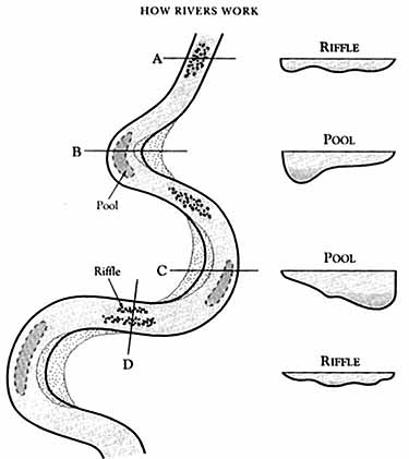
The son of famed environmentalist Aldo Leopold, who often was called the father of wildlife ecology, Leopold was the first to turn a scientific eye on rivers and streams and draw conclusions about their form and evolution. Long before fractals became an everyday word, he realized the similarity between large- and small-scale characteristics of streams.

"He made crucial discoveries about the nature of rivers, especially their remarkable regularity," said William Dietrich, a UC Berkeley colleague of Leopold's and a professor of earth and planetary science. "He showed that this regularity of form applies to all rivers, whether they are in sand boxes or draining entire continents, at scales of a laboratory flume or the Gulf Stream."

Leopold was a "quantifier" who took notes on the natural world and wrote papers on everything from Hawaiian dew to energy expenditures in rivers, and even on the esthetic value of rivers, said Dietrich.

"He was a clear voice and advocate for ethics in science and a defender of the value of esthetics as a reason to protect the natural world, even going so far as to propose a quantification of esthetics," he said.

Leopold developed his expertise during a 22-year career with the U.S. Geological Survey (USGS), rising eventually to the level of chief hydrologist of the Water Resources Division.

"In effect, Luna turned the hydrologic division of the USGS into a premier research organization, contributing to the prominence the field now has," Dietrich said.

The Virtual Luna Leopold Project

On February 23, 2006, Luna Leopold died at the age of 90. Luna was a vital force, a man of extraordinary creativity and originality, whose passion about science and the natural world permeated all he did. He wrote with a clarity, simplicity, and insightfulness that inspired generations of researchers. Nearly all of Luna’s papers precede the time when publishing houses make pdf’s available. In order to avoid Luna’s seminal papers becoming “classics” (papers often cited but never read), we have created a web page where the majority of Luna’s papers have been scanned and made available on line as pdf’s. Luna assisted with this work, reviewing the publication list and helping us find originals of papers.

Visit the web page which contains a list of Luna’s publications and pdf copies of Juna's work.

Virtual Luna Leopold


Monday, December 26, 2005

Prefabricated Houses 'Breezehouse'


Prefabricated houses are great because less energy is consumed building them, less material is wasted and they are so much more airtight. One of the big drawbacks of modular construction is the cost of shipping so much air- some of the savings that come from working in a factory close to your workforce are lost in taking all of the pieces to the jobsite. Thats why we like Michelle Kaufmann's Breezehouse so much.

In this design, the complex and expensive stuff, like kitchens and bathrooms, and the small stuff, like bedrooms and closets, are done in the factory in fairly traditional modules. This is where the factory shines, and the value of the box is fairly high because all of the expensive stuff is here.

then, when these two boxes are brought to the site, a roof is installed on site from prefabricated trusses, and two end walls are put on. There is more site work required than a normal prefab, but it's not complex work and it only requires a few trades.

The Breezehouse takes advantages of the virtues of modular construction and leaves its biggest problem, the cost of shipping air, behind.

Monday, October 17, 2005

Do you know what kind of fish this is?

You could win $3453224523443.43, nah sorry, but you would confirm your extensive knowledge of fish species.


Thursday, October 13, 2005

Tips to get ecology, natural science, biology jobs in the government
More info will be coming soon!

Does Ecological Restoration Work? or are we fooling ourselves?


Wednesday, October 12, 2005

River/Watershed Ecology and Restoration

Journal Article Review/Opinion

The Network Dynamics Hypothesis: How Channel Networks Structure Riverine Habitats. BioScience: Vol. 54, No. 5, pp. 413–427.
LEE BENDA, N. LEROY POFF, DANIEL MILLER, THOMAS DUNNE, GORDON REEVES, GEORGE PESS, and MICHAEL POLLOCK
"Figure 4. (a) Network patterns and the associated basin shapes affect the downstream sequence of confluence effects. Common network patterns include dendritic networks, within heart-shaped and pear-shaped basins, and trellis networks, within narrow, rectangular basins. (b) The anticipated downstream sequence of confluence effects (ranging from high to low likelihood) is based on the size of the tributaries relative to the main stems. Dendritic networks in heart-shaped basins promote the greatest likelihood of confluence effects downstream, while trellis networks in rectangular basins promote the fewest effects downstream. Modified from Benda and colleagues (2004)"

My rant:
This is a very thought provoking article which links a spatial and temporal context to established ecological principles. In my opinion this information may help explain some conflicting results from seemingly similar studies when placed in the context of where along the stream network these studies were conducted. Many still view natural systems as static. In restoration much of the objective is to resotore a certain site to a previous condition. These natural systems however may be in a constant state of change. This 'change' is sometimes viewed as detrimental but may be a natural progression of the system. Organisms may rely on this change for survival. For example, spawning salmon may rely on disturbances like landslides which provide new gravel for spawning. "anything can be toxic given a high enough dosage". The challenge is determining how much constitutes a 'bad' or detrimental amount. Another consideration is what may be beneficial to one species may not to another. In this way the Endangered Species Act can be detrimental to naturaly ecosystems...But that can be saved for another discussion.
All in all, this article provides a template for which new field studies can be tested, always exciting!

Monday, October 10, 2005

Current Research

My current work is focused on examining juvenile coho food resources during the winter. The winter can be a time when food resources are scarce or the environment is harsh. In the Pacific Northwest winters are typically wet with frequent floods. These floods can displace juvenile fish as well as affect their food resources by displacing invertebrates or making it difficult for fish to capture because of high turbidity or water velocities.
What I have found however is that floods of lower magnitude are beneficial to fish. They can dislodge invertebrates and make them more susceptible to fish. The dislodged inveretebrates can enter the water column where these fish generally feed.

Saturday, October 08, 2005


Mount Hood is a dormant stratovolcano in northern Oregon, in the Pacific Northwest region of the United States. and is located about 60 miles (100 km) east of the city of Portland. Its snow-covered peak rises on the border between Clackamas and Hood River counties. It is the highest mountain in Oregon and the fourth-highest in the Cascade Range. It can be seen easily from both Portland and Vancouver, Washington. The eroded volcano has had at least four major eruptive periods during the past 15,000 years. The last three occurred within the past 1,800 years from vents high on the SW flank and produced deposits that were distributed primarily to the south and west along the Sandy and Zigzag rivers. The last eruptive period took place around 170 to 220 years ago, when dacitic lava domes, pyroclastic flows and mudflows were produced without major explosive eruptions. The photo was taken in late September of 2005 of its west facing slope.

Thursday, June 16, 2005

Columbia River

Columbia Gorge dividing Washington and Oregon States. Much of the Columbia River is backwatered acting as a lake due to large hydroelectric dams. These dams have changed the natural ecology of the area. Some effects are; reductions in salmon populations and increases in invasive species.


It is intended to post and stimulate converstation revolving around intersting articles related to stream ecology, fluvial geomorphology, fisheries, and hydrology fields, and whatever else I feel like posting.